
Walk a Maricopa County Street
A reliable street-by-street search starts with the county property roll. The Assessor ties a physical address to an Assessor Parcel Number, or APN, plus an indexed owner and land references. That does not prove who sleeps at the address. It does create the best bridge to the map, Recorder, and Treasurer. Keep the situs address, owner name, APN, subdivision, MCR, and section-township-range fields separate as work proceeds.
- Enter a full address or street phrase in the Maricopa County Assessor search. Classify the result as real property, rental property, mobile home, business property, or subdivision.
- Open the address link in Parcel Viewer. Confirm the parcel shape and inspect the lots along and across the street.
- Record the APN and legal or plat references. These identifiers remain useful when postal wording has changed.
- Carry the current owner and legal description to the Recorder index. Match deeds by party, instrument, and land description.
- For an older household question, use a street-ordered directory or census as separate evidence. Never relabel a listed owner as a resident without support.
This order prevents a common mistake. The Maricopa County street directory is not one master file. It is a chain of records with distinct meanings. A deed proves a title event, the Assessor identifies the indexed owner, and a reverse directory reports a historical listing at a street address.
Search Maricopa County Streets
The Maricopa County Assessor MCS is the main address-first portal. Its universal field is labeled “Search parcels and addresses,” uses the query parameter q, and rejects queries of two or fewer characters. A street directory query can return more than land parcels, so read the result-group heading before using a name.
| Result family | Fields shown | Street-directory value |
|---|---|---|
| Real Property | APN, owner, address, subdivision, MCR, S/T/R, property type | Connects a situs address to a parcel and indexed owner |
| Rental Property | APN, address, owner, contact, agent, property | Flags a registered rental, but does not identify occupants |
| Mobile Home | Account, name, location, up to four VIN fields | Separates mobile-home results from ordinary parcels |
| Business Personal Property | Account, name, address | Prevents a business account from being mistaken for a household |
| Subdivision | Subdivision name and parcel count | Groups land records under a recorded development name |
The portal links the APN to detail, the owner to another name query, and the address to Parcel Viewer. Subdivision, MCR, and section-township-range values also open their own search modes. Export is capped at 1,000 records, which matters on long or common street names.
The official Assessor search-help page shows how the county handles parcel and address queries.
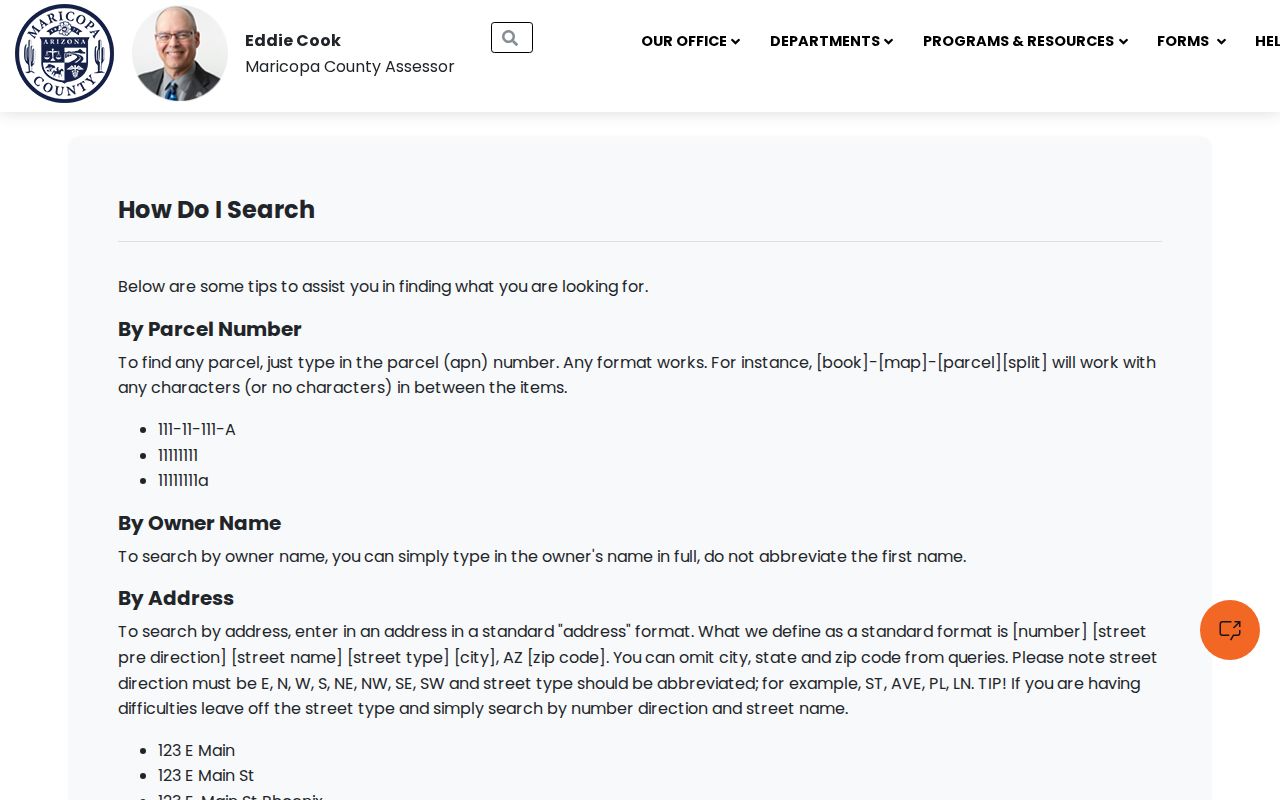
The captured help screen is a useful fallback when the universal search mixes several result families or a street phrase is too broad.
Note: A registered-rental marker describes the parcel record, not the name of any person living there.
Maricopa County Address Record Chain
Address-keyed sources overlap, but none should absorb the meaning of another. The street directory becomes more accurate when the physical parcel, title chain, tax account, and historical listing retain their own labels. If an online portal fails, use the documented support route or office request rather than guessing at a missing field or date.
| Address source | Official keeper | Evidence supplied | Access route |
|---|---|---|---|
| Current property roll | Maricopa County Assessor | APN, indexed owner, situs, land references, type | Free MCS search, inquiry, appointment, or public counter |
| Parcel geography | Assessor Parcel Viewer | Parcel footprint and adjacent APNs | Free map launched from an address result |
| Recorded instruments | Maricopa County Recorder | Deeds, liens, plats, parties, and title sequence | Online index or focused records request |
| Property tax account | Maricopa County Treasurer | APN-linked tax status and account context | Online portal after the APN is known |
| Phoenix permit activity | Phoenix Planning and Development | Project and permit evidence tied to a place | SHAPE PHX or city records request |
| Historical street listing | Arizona Memory Project and State Research Library | Listed householders and addresses in covered years | Digitized volume, catalog, or reading-room appointment |
The Recorder’s Recorded Document Search is the online starting point for deeds and other instruments. Its precise online start year, complete controls, and current copy fees were not verified. When it blocks access or stops short, use the Recorder’s public-record request routes and ask for the named index, date range, parties, and land description.
Map Maricopa County Street Parcels
Each MCS address result supplies a direct route to the Assessor Parcel Viewer. The map URL carries the APN through an esearch value, which is safer than trying to relocate the lot from scratch. Center the selected parcel, inspect polygons on both sides of the street, then open each APN back in the Assessor roll.
The Parcel Viewer search and buffer help documents map search and selection mechanics.
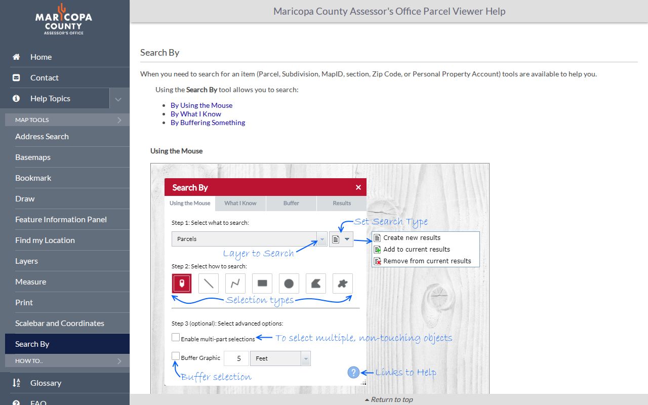
The viewer adds spatial context to a by-address list. It still reports geometric neighbors and parcels, not social ties or household members.
- Parcel
- A mapped unit of land identified by an APN in the county property system.
- Situs address
- The physical location assigned to the parcel, distinct from an owner’s mailing address.
- Plat
- A recorded map that lays out lots, blocks, streets, and other subdivision features.
- Criss-cross directory
- A historical directory arranged by street and house number instead of only by a person’s surname.
Maricopa Street Names Can Shift
The APN and legal description are the durable bridge when a street directory search meets older wording. A legal description identifies land through a lot, block, subdivision, plat, or survey framework. It can survive a new street name, a changed number, or a different postal city label. MCR refers to the county’s recorded-map reference, while section-township-range helps locate rural or unsubdivided land.
That distinction is vital in fast-growing parts of Maricopa County. A postal “Phoenix” label can sit in a county island or another jurisdiction. Permits follow the government with authority over the place, not just the city printed in a mailing address. The county’s current street-centerline data even carries a jurisdiction field that can distinguish Phoenix, private streets, Maricopa County, and other authorities.
Insider tip. Preserve the APN, MCR, subdivision, and legal description before leaving the Assessor result; they reconnect a changed address to its map and deed trail.
Phoenix Street Directory Grid
Phoenix’s grid explains why a number alone is not enough. The official street-naming process places Avenues west of Central Avenue and Streets east of Central, followed by other suffix families farther from the center. Thus 7th Avenue and 7th Street lie on opposite sides of Central. East-west, angled, and loop roads follow separate naming rules.
The county address and intersection geocoder help accepts house number and name, with optional direction, type, and ZIP. Intersections need at least one street type plus an ampersand or the word AND.
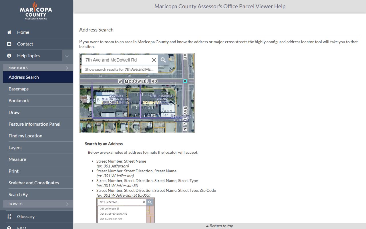
The geocoder narrows map placement. It is not evidence that a person resides there, and its suggestions show only ten matches even when more exist.
Phoenix history adds another trap. Washington was the broad main street of the first townsite, and north-south streets once had names before they became numbers. Center Street had become Central Avenue by 1873. For old records, search both the period wording and the land identifiers.
Follow Maricopa Street Deeds
A postal address leads to title history only after the current owner and land description are known. Search that owner in the Recorder index for an acquisition deed. Record the recording number, date, instrument type, grantor, grantee, and legal description. Then search the seller as a grantee to find the earlier transfer. Repeat while the legal description continues to match.
This backward chain identifies past owners, not every past resident. A seller’s later deed can suggest another property connected with that name, but it does not prove a move or residence. The Maricopa County Treasurer adds parcel-tax context after the APN is known, yet a taxpayer or mailing contact is also not an occupant.
When online entries end, ask the Recorder for older grantor and grantee indexes and deed books. The research did not verify the portal cutoff or the physical extent of older books, so no year should be assumed. A focused request should state the party, approximate date, recording number if known, and exact legal description.
Maricopa Street Permit Evidence
Inside Phoenix, SHAPE PHX connects addresses to planning and permit activity. A permit can date construction or alteration and may name an applicant or project contact. It cannot establish who occupied the site. The portal’s exact fields, coverage dates, fees, and export controls were not captured, so searches should stay within controls the live service actually presents.
The SHAPE PHX capture shows the official entry point for a place-based permit check.
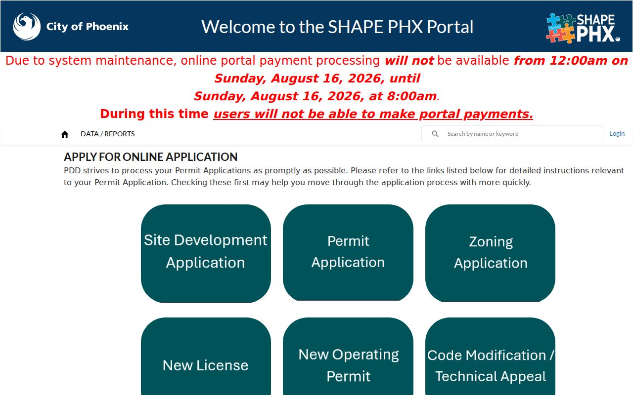
Match any project name to the parcel roll and deed record. If the address sits outside Phoenix, first identify the correct city or county jurisdiction, then use that custodian’s permit or records-request channel.
Older Maricopa Streets by Address
Historical reverse directories answer a different street question. The 1955 Phoenix Mullin-Kille volume includes a Householders’ Directory and Street Telephone Guide arranged by address. It can show a listed householder, home-ownership mark, and telephone number for that edition. The result is a canvassed snapshot, not legal title and not a full count of everyone in the household.
Use the street division to locate an address, then compare the resident division for initials, spouse, dependents, position, employer, home address, and phone fields. The complete collection history belongs on the Maricopa County city directories page. For street work, the key point is that the address order can fill an era gap between deeds and census schedules.
The State Research Library holds more years and places in print than appear online. Its Reading Room uses appointments, while the Arizona Memory Project supplies digitized volumes. An absent online year is not proof that no directory exists.
Note: Historical directory entries may be stale, misspelled, or omitted, so compare adjacent editions and an independent public record.
Maricopa Street Directory Limits
No Maricopa County property tool provides a complete public roster of people inside a home. Owners may live elsewhere. A mailing address can be a post-office box or another property. Rental registration identifies an owner, contact, or agent, not the renter. Parcel Viewer supplies shapes and APNs, while private utility, delivery, and motor-vehicle address data remain outside this official street chain.
Voter material also is not an unrestricted household browser. The Recorder’s individual registration request requires a full name, date of birth, and last known addresses. Broader voter files have uses limited by Arizona law, and protected voters are withheld. Do not turn those records into a by-street resident list.
Lawful use. Use Maricopa County address records for family history, title research, consumer safety, and civic curiosity. Arizona law does not permit stalking, harassment, threats, or efforts to defeat protected-address programs.
A commercial compilation may merge stale sources or attach the wrong person to a parcel. Official records are stronger because each has a named custodian and a defined purpose. Even so, the Maricopa County street directory must label an owner as an owner, a listed householder as a historical listing, and an occupant only when the evidence truly supports that claim.